
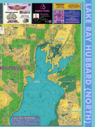
Page 7 - Lake Ray Hubbard Lake Map, 1st Edition
P. 7
ark
Kreymer Estates Park ical Miles
96.50833° W
430
BENNETT RD
438
4
4
4
437
v
R
439
y
it
441
in
441
4
k
436
F
tr
4
441
3
3
s
E
o
4
8
A
8
438
437
429
9
WINDY KNOLL LN
437
4
E OAK ST
L
3
436
N
3
3
439
L
437
438
444
437
437
438
438
437
438 3
4
6
e
3
4
2
F
T
0
444
vr
437
436
436
3
4
2
W
438
439
y
437
3
i
BESSIE ST
1
in
r
436
436
4
T
437
i
r
436
I
e
437
438
C
U
436
E
E
R
439
T
436
L
423
4
E
2
O
A
437 437
436
E
4
M
Y
4
Rush Creek
437
436
L
436
8
O
U
H
F
436
3
4
O
N
4
O
E
439
X
s
8
437
R
6
W
3
4
438
3
436
7
437
436
T
4
O
7
442
4
N
RICHLAND CHAMBERS CT
424
4
438
437
436
3
3
4
r
e
L
440
6
437
C
436
436
436
5
v
449
D
4
r
438
4
R
3
6
4
H
6
3
S
t
4
o
438
436
STONEHEDGE DR
4
435
3
H
Bozman Farms Estates Park
33
WHEELIS RD
BETTY ST
SHERRY LN
P
437
441
A
4
436
L
L
7
R
D T
P
4
E
u
W
436
H
4
Y
3
6
N
ao
A
A
S
A
436
437
423
R
4
T
436
438
444
V
N
B
R
C T
CE C
L
439
R
D
BE
R
4
A
E
R
436
D
3
6
r
435
A
6
GALACINO LN
L
t
442
M
3
7
L
R
I
T
436
432
445
H
436
U
D
435
438
4
437
N
4
T
W
D
S
O
O
E
C
436
437
R
436
436
R
9
436
S
437
4
436
435
437
E
436
S
CRESCENT OAK ST
436
3
R
O
437
4
H
O
544
33
33
435
3
436
436
4
E
N
R
438
437
4
F
k
4
436
436
3
437
C
436
N
437
436
436
435
9
435
R
A
k
436
E
e
N
436
436
W
436
436
O
N
436
6
4
448
I
D
4
2
O
436
445
7
Y
6
G
C
T
5
C
R
436
S
436
E
436
L
E
4
L
L
438
6
435
I
437
K
H
436
436
S
I
436
9
435
R
437
B
D
2
436
L
422
B
4
435
V
448
4
D
4
437
4
N
a
S
T
4
437
D
H
4
6
C
437
I
3
r
L
438
I
G
s
A
449
3
NL
7
436
R
I
3
D
R
436
R
ROBERTS RAVINE RD
T
4
436
E
436
PHEASANT XING
L
K
2
i
h
436
436
4
LA
437
4
7
436
E
BOBCAT TRL
438
C
4
3
2
436
C
4
437
4
L
r
e
4
432
e
R
4
422
N
436
G
6
443
439
TRAIL SIDE RD
437
436
437
4
437
425
436
4
437
437
436
426
O
W
436
R
4
436
436
ROD
436
L
439
436
437
0
436
449
D
436
4
D
448
36
437
ELI CT
4
436
437
436
3
436
O
N
D
I
441
442
424
4
4
437
437
G
436
N
WILDWOOD LN
3
437
436
4
N
E
945
M
436
436
A
436
437
440
E
443
437
437
D
LYNCH CT
437
436
4
437
O
439
442
6
435
4
3
il
449
4
436
R
D
437
4
426
436
5
MOSSY OAK LN
N
440
437
438
L
U
G
436
O
446
3
4
6
4
H
3
445
4
O
435
I
D
6
2
6
SQUIRREL RIDGE
R
R
436
4
440
u
D
s
9
h
436
438
C
442
4
436
r
437
e
3
k
430
3
436
436
4
440
6
436
430
FOX HOLLOW
A
WYLIE EAST DR
437
437
436
7
436
4
439
A
442
8
3
7
436
WESTLAKE DR
CINDY LN
DUCK BLIND AVE
COUNTRY PLACE LN
437
4
449
9
437
431
444
449
4
440
437
436
4
3
4
437
7
431
438
436
437
k
V
430
OAKHURST CT
E
435
437
436
438
436
V
4
6
431
HILLSIDE DR
437
436
N
G
437
441
437
4
442
435
436
436
E
446
R
435
E
A
K
R
437
4
A
7
435
o
4
436
9
W DR
KERNVILLE DR GOLD HILL DR
PE
3
O
NEVA LN
4
3
437
6
437
3
4
7
437
A
4
436
437
439
3
M
3
D
E
4
L
P
439
437
437
437
3
3
436
436
T
436
4
0
O
436
449
HELDON DR
E BROWN ST
WOODMEADOW CT
I GV
WHITNEY LN
438
D
438
3
440
6
436
N
I
4
4
436
442
437
4
432
4
E
436
431
437
438
441
V
L
436
436
3
429
D
A
6
4
W
W
437
437
437
437
437
JADE
440
436
436
4
I
437
444
N
427
431
447
445
436
L
438
L
436
437
Pilot Grove Creek
3
6
LAKE TERRACE DR
East Fork Trinity River
MOBLEY LN
440
4
448
441
L
L
7
442
L
N JOHN KING BLVD
436
A
K
436
4
436
G
e
438
4
E
436
4
436
437
MISTY WAY STA DR
436
HIDDEN HILLS
436
437
436
4
Lakeside Park
Jewel Park
se 1 Park
544
Pheasant Creek Park
4
438 436
437
.98333
96.51667°W
Avalon Addition Phase 1 Park
96.49167° W
Shiloh
96.48333° W
96.475° W
.98333
COLLIN COUNTY ROCKWALL COUNTY
.98333
COUNTY LINE RD
MEADOW BLUFF DR
449
e
G
430
6
4
436
L
U
T
A
V
K ST
6
N
438
4
TOPAZ CIR
429
3
E
3
D
ETHAN LN
7
PATRICIA DR
436
R
TROY RD
A
430
3
436
436
T
436
439
4
4
446
4
4
SUNRISE DR
3
3
429
429
437
3
439
CI
R
PEARL RD
437
437
4
onwood Creek
E
436
N
442
436
C
I
431
H
A
N
7
T
M
KREYMER LN
H
449
E
N
C
W
4
E
436
438
429
428
436
U
430
TF
S INVERNESS WAY
427
L
445
431
R
429
OLD TROY RD
5
Cottonwood Creek
4
S
V
A
BEAVER CREEK RD
3
M
WHITMAN DR
430
428
428
429
436
CAROL LN
JASON ST
449
O
436
4
427
6
438
I
442
428
E
436
SURREY CIR
427
D
436
4
C
I
449
449
437 437
436
.96667
Old Veterans
.96667
.96667
DALTON RD
.96667
CAMELOT DR
MAJESTIC WAY
RAY HUBBARD WAY
Y
6
D
WOOD LN
LAKE TRL
A
SHADY VISTA WAY
S
N
N
2
442
R
JEANNE LN
4
A
6
N
4
431
S WA ALLEN BLVD
V
R
HUNT LN
4
W
449
435
RD
9
V
435
t
S
H
4
428
437
438
4
PROMENADE PL
ALL ANGELS HILL LN
E
ROSE DR
4
W
437
448
AVONLEA DR
9
N
L
2
R
4
D
N
Avalon Phase 2 Park
LLIN COUNTY
EXAS
205
205
Eureka Park
D
LADUE RANCH
WALDEN RANCH
96.5° W
96.46667° W
437
E
437
449
6
A
A
9
436
S
448
429
D
428
430
431
436
424
LAURELCHERRY LN
436
437
439
440
426
436
MCGEE COVE RD
ER
436
3
444
3
WHITNEY LAKES DR
A
SHORES BLVD
Y
R
436
6
PENINSULA DR
436
N
HARLAN DR
I
437
437
U
6
4
436
9
O
L
438
3
L
R
V
Lake Ray Hubbard Coordinates: 32.799444°N, -96.495°W
Year impounded: 1968
Surface area: 22,745 acres (9,205 ha) Max. depth: 40 ft (12 m)
Surface elevation: 435.5 ft (132.7 m)
D
R
Grayhawk Park
33
HE NT
.98333
Dallas
WARNING: THIS WATER BODY MAY HAVE MANY SUBMERGED HAZARDS.
Shores Park
Be observant and cautious.
Be aware that buoys are subject to be shifted out of position resulting from stormy waters, drift or other accidental causes. Please proceed with caution.
DISCLAIMER
The original maps and data used to create this publication were provided by state, county, and local tion were provided by state, county, and local govern- land before visiting. We cannot be held liable for any
The original maps and data used to create this publica- only. Always check if locations are on public or private
governments who have assured us the information is the most recent available. Due to fact the ments who have assured us the information is the most trespassing. Trespassers may be prosecuted.
original drafting process is based off that information we cannot be held liable for any inaccuracies recent available. Due to fact the original drafting process While we make every effort to ensure accuracy and
or omissions.
is based off that information we cannot be held liable for completeness, we would appreciate any input regarding
any inaccuracies or omissions.
Some roads, especially unmarked roads, may be private. Legend icon locations are for informational
purposes only. Always check if locations are on public or private land before visiting. We cannot be Some roads, especially unmarked roads, may be private. next publication. Thank you.
held liable for any trespassing. Trespassers may be prosecuted. Legend icon locations are for informational purposes
While we make every effort to ensure accuracy and completeness, we would appreciate any input regardinDg eerrodrsiocraomteissdiontsoso Htha.tAth.eyFmualylberco-rSreuctetdhineorulranenxtdpu,bFlicoatuion. Tdhaenkryou.
Copyright © 2020 Copyright1s©tE2d0it2io1n,CAolplyRriighht©ts2R02e1servedby:
LIBERTY MAAll RigKhEtTs RINesGervCeOdMbyP: ANY, INC. ReLpIrBodEuRctTioYn oMf tAhiRs mKaEpTinINpaGrt CorOinMitsPeAntNireYt,y IwNitCho.ut
204 Nt.hWeEeSxTprSeTsRs EwErTitt•eAnRcLoInNsGenTtOfNro,mTXLi7b6e0rt1y1M• a8r1k7e.t8in6g0.3110
written consent from Liberty Marketing is strictly prohibited.
L
436
BOZMAN RD
I
A
E
E
437
7
D
442
L
E
AR
446
A
3
A
GLENCOE DR
O
6
7
437
D
4
444
BUTLER RD
S
WINDHAM DR
448
440
436
G
COLLINS BLVD
HIDDEN VALLEY CIR
DESTINY CT
RL
GLENDALE DR
RIVERSIDE OAKS DR
E
9
T
437
R
BARLASS DR
E
E
205
is strictly prohibited.
www.LibertyMapAds.com
LIBERTY MARKETING COMPANY, INC. Reprod2u0c4tiNo.nWoefstthSist.m•Aaprlingptaornt,oTrXin76it0s1e1n•tFiraext:y(8w1i7th)o8u60t-t7h1e1e3xpress
817.860.3110 • www.LibertyMapAds.com
errors or omissions so that they may be corrected in our
Rockwall
STRINGFELLOW LN
OAK HOLLOW LN
448
6
441
444
435
436
438
A
446
437
6
DE
I
L
S
439
438
E
439
A
32.95833° N
32.975° N
32.99167° N
33° N
33.00833° N
33.01667° N
.46667 32.96667° N
.46667 32.98333° N
.46667
.51667
.51667
.51667
.5
.5
.5
.48333
.48333
.48333
429
436
N GOLIAD ST
430
431
I
4
D
D
4
N
R
I
RIDGE DR
9
443
S
8
R
R
S
R
R
H
436
LAKE RAY HUBBARD (NORTH)
T
D
O
7
D
437
441
440
435
E
442
5
Q
3
A
D
A
442
436
437
Parker
Y
E
445
HOLDEN DR
4
V
448
PLUMMER DR
430
448
445
438
W
E
4
G
N
W
U
446
Y
IL
3
RN
4
